
As colonists began settling along the eastern seaboard in the late 1660s and early 1700s, they realized the need for accessible routes between those settlements. Trails used by the local Indian tribes were the first means of getting from one place to another. These trails often followed the natural landscape, moving through the region’s river valleys. As more people flowed into the area and settled, the need for a regular mail route also became apparent. Postal trails developed where the Indian trails were and later became roads for wagons and stagecoaches as people began to move down the Atlantic coast.
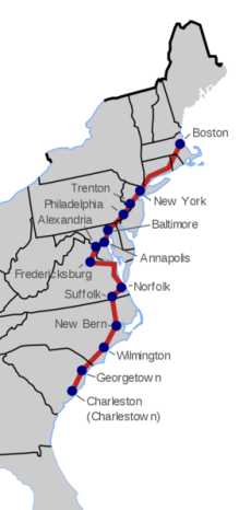
By 1750, the King’s Highway, a stretch of road about 1,300 miles long, from Boston, Massachusetts to Charleston, South Carolina, was built. It carried people as they settled new areas or used the road to take their goods to sell at markets further away.
The building of the King’s Highway was originally a request in 1664 from England’s King Charles II for a road between Boston and New York City. The King’s Highway was also known as the Boston Post Road, the Great Coastal Road, the Potomac Trail or the Charleston-Savannah Trail. By the time the American Revolutionary War began, the name The King’s Highway had fallen out of favor, although the road was often used by both sides.
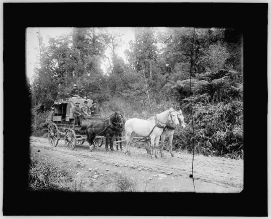
The Boston Post Road is known as the oldest land trail and was used to carry the first mail. That first trip, made in 1673, took about 4 weeks to cover 250 miles. In the beginning, post riders carried the mail by horse on the small trails created by the Indians of the area. Theirs was a hazardous job, made difficult by frequent snow storms in the winter, summer heat, and spring rains turning the road into muddy swamps. Later, the road was widened to allow for stagecoaches and horse-drawn wagons. And later still, turnpike companies took over and began to improve small pieces of the road.
Do you have ancestors who moved down the eastern seaboard? Does their journey follow closely the known trails and roads of the time?
Why it’s important to learn about migration routes
Migration patterns influenced our ancestors more than we might first imagine. The decisions they made to move to a new location were influenced by the climate, geography and migration routes known of at the time. Water ways provided the quickest method of transportation before roads and railways. Canals made it easier to reach areas further inland and brought families to the villages and towns springing up near the canals.
Knowledge of geography, history and transportation will help in understanding why our ancestors settled where they did and why they may have moved on when they did. Start at the end…that is, start with the last place you find your family and work backwards, following each move. Create a list of each location and learn about the geography and history of the area. As your ancestor moved, he may have generated records in areas that you may not have thought to search in. Timelines are a great way to plot the dates and places you find your family in. They will easily show the gaps in time where you may have ‘lost’ your family. Knowing the migration routes of the area may help you find them again.

I have included your blog in INTERESTING BLOGS in FRIDAY FOSSICKING at
https://thatmomentintime-crissouli.blogspot.com/2018/11/friday-fossicking-23rd-november-2018.html
Thank you, Chris
LikeLiked by 2 people
Thank you, Chris! Very much appreciated.
LikeLiked by 1 person
You’re welcome..
LikeLiked by 1 person
Great reminder of the importance of knowing the migration routes of our ancestors, Sue!
LikeLiked by 2 people
Thanks, Liz! It was a good reminder to myself too to look at every angle and every reason why an ancestor relocated in the way they did. Thanks for stopping by!
LikeLiked by 2 people
What a great tool! I need to take a little more time to study the migration routes that my ancestors would have taken to get out to the Midwest. Several of them started in the Northeast, moved to Ohio, then ended up in Illinois. I’m suspecting that they moved along a migration route to get here!
LikeLiked by 2 people
EvaAnne, I have some family who took that same route! I’ve been working on plotting their journey and looking at migration routes which may have influenced their decision to move. Will let you know what I find! Thanks for stopping by!
LikeLiked by 2 people
A great post involving two of my favorite research tools—Timelines and Maps(needed if you are looking at migration patterns) Timelines are maps of our lives.
LikeLiked by 2 people
I agree Marie, love using timelines and maps in my research!
LikeLike
The migration routes within the US I’ve seen with my family are more regional. I think I’ll map them to see what they actually look like.
LikeLiked by 1 person
I’m doing the same thing, Liz. Hoping to find one particular family who disappeared for about 10 years before popping up in Iowa.
LikeLiked by 1 person
Interesting history. I like the idea is tracing backwards.
LikeLiked by 2 people